
Ben Thompson
Americans generate trash at an astounding rate with nearly 251 million tons of trash produced per year. Landfills have become generally unpopular in recent years as America’s attitude toward landfills has changed radically. Alternative strategies such as waste reduction and recycling are becoming increasingly popular. The amount of landfills have dramatically decreased since the 1980’s, not only due to society’s changing attitudes over them, but also because a significant amount of the landfills have failed EPA regulations. However, it is inevitable that a new landfill would result in higher revenue. Having a regional landfill within Charlotte County would be economical for a variety of reasons. For example, they would not have to pay the transportation cost of shipping waste out of the county and regional landfills often attract large industry into the county. Perhaps the most important reason stems from the fact that the current landfill within Charlotte county, Zemel Road Landfill, is only projected to until the year 2030. It is imperative that the county begin planning a new landfill site in order to maximize the county’s revenue and maintain a stable economy. Despite the environmental concerns that surround landfills, recent research has shown that treatment facilities are capable of removing nearly all of the trace contaminants within the landfill.
Designing a suitable location for landfills is the most important process in planning for future landfill location. A particularly useful method of finding the most suitable landfill is through the use of Geographic Information Systems (GIS). GIS provides an easy to read visual interpretation of suitable locations. GIS also has specific spatial analysis tools incorporated into its software that help the user select the most suitable areas. In the maps below, the weighted overlay spatial analysis tool was utilized in selecting the most suitable landfill for Charlotte County. The factors that contribute to the most suitable landfill site are complex. Much of the data is also unavailable, and would consequently have to be collected or researched. Only a few of the important factors were used to determine suitable locations. All of the following shapefiles containing data were extracted from the Charlotte County, Florida Governmental Portal and include the following: FEMA flood zones, soils, existing land use, future land use, streets, and vulnerability to storm surge. As mentioned above, the weighted overlay tool was utilized with the above data to find the most suitable landfill areas. Weighted overlay was used because it is one of the most efficient and easiest approaches to use when performing the suitability analysis.
Before using the tool, the input data was defined based on what would be suitable for landfills. The attributes had to be examined within each shapefile to determine what data should be selected. The following data within each shapefile was selected for weighted overlay analysis: flood zones that were outside “FEMA flood zones”, vacant property in “existing land use”, fine and depressional soils in “soils”, and areas outside of “vulnerability to storm surge”. Areas outside of flood zones were chosen because flooding presents environmental risks that include leaching of pollutants into the groundwater and methane generation into the atmosphere. Storm surges present similar environmental risks, which is why only the areas outside of storm surges were selected. The fine and depressional soils are the most impervious to water and waste that could potentially leach below the ground. Lastly, vacant property would be the ideal locations to construct a landfill for the community in order to avoid any land issue discrepancies.
Each input is then reclassified to a value of 1 or 0 (suitable or unsuitable). The weighted overlay tool (i.e. raster calculator) then multiplies the cell values of each input by the weight of importance. All data was weighted equally in this case. The resulting values are then multiplied together to produce the suitable landfill areas. The weighted overlay tool produced the map below:

The suitable landfill areas are widely dispersed throughout the county. The weighted overlay tool was executed further for streets and environmentally important areas separately with the first produced output of suitable locations. Constructing landfills on areas categorized as not environmentally sensitive are particularly important as landfills have potentially devastating impact on the environment. Landfills close to roads are important to reduce the transportation cost of moving waste into the landfills. Areas that were close to streets and environmentally important areas were reclassified with the number 2 while all other areas were reclassified with the number 1. The purpose of the reclassification is to display the suitable areas that are close to roads or environmentally sensitive to the areas that are not. Streets were buffered one-fourth of a mile and used in the weighted overlay tool with equal weight to the first map, and the zoning areas deemed environmentally sensitive and the future land use planned for natural resource conservation and preservation were used in the weighted overlay tool with equal weights to the first map. The resulting maps are below.

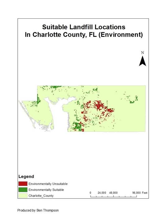
The resulting maps are similar. The areas in the middle of the map are environmentally unsuitable and distant from roads. There are a few preferred areas in the center of the map, two large clusters in the northwest region of the county, and a large cluster of areas on the eastern side of the map. After examining aerial photography of the county, the cluster of area in the east was found as the most suitable area for a landfill. Aerial photography showed that a large proportion of the area mid to western section of the county was covered by water. Most of the western part of the county also consists of residential neighborhoods. The map of suitable areas in relation to water cover is shown below.

Selecting the suitable locations for landfills is an extremely complex process that is greatly limited to the data available. Numerous factors were considered in the analysis, but are certainly not limited to only those used. No weights were used, except when comparing areas environmentally sensitive and areas close to streets to areas that were not, because the importance of many of these factors is still up for debate. However, the resulting green areas distant from water in the map should be considered for a new landfill in Charlotte County while further research and planning should begin as the current landfill reaches the end of its life span.
Contact: THOMPS48(AT)ILLINOIS(DOT)EDU
Disclaimer: This study was conducted as part of a course requirement for UP 418 (GIS for Planners) at the University of Illinois at Urbana-Champaign. As a class project it may lack analytic rigor, data accuracy, and validity. Findings of this study can only be shared, disseminated, or reproduced after getting consent from the student and the instructor.